


Britons have been warned to brace for colder conditions after a weather phenomenon disrupted the polar vortex.
The Met Office confirmed that a sudden stratospheric warming (SSW) took place yesterday, disrupting the stratospheric vortex around 30km above the surface.
Forecasters have stressed that low pressure will continue to bring changeable conditions, particularly across southern areas, while drier, brighter weather will continue further north.
They warn that this weekend, particularly Friday night into Saturday, will be turning particularly cold.
Temperatures could fall to around -8C or -9C in parts of the country.
Wet weather is then expected to move in from the west later on Saturday, with somewhat milder air.
However, the Met Office assures that the recent cold weather experienced across the country isn’t the result of the sudden stratospheric warming.
Forecasters explain that it usually takes around two to six weeks for changes in the stratosphere to feed down and potentially influence weather near the surface.
Explaining the phenomenon, the Met Office said: “During autumn and winter, extremely cold air develops high above the North Pole. Strong westerly winds circulate this cold air, forming what we call the stratospheric polar vortex.
“Sometimes, large atmospheric waves can disrupt this circulation, causing the winds to weaken significantly or even reverse direction.
“Temperatures in the stratosphere can then rise rapidly, hence the name sudden stratospheric warming.”
Towards the end of October, a strong wave two pattern squeezed and weakened the polar vortex.
LATEST DEVELOPMENTS
- UK weather: Snow hits parts of UK as Britons warned of traffic delays and potential power outages
- Met Office issues weather warning for snow as forecasters warn of disruption
- Yellow health alerts issued for millions of Britons as temperatures set to plummet across England
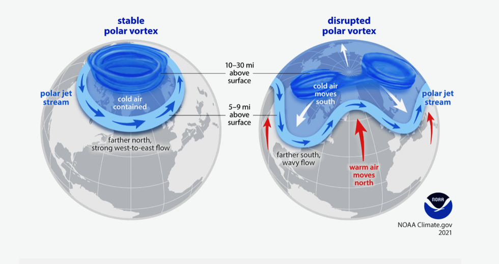
In November, this was followed by a wave one event, which appears to have pushed the vortex further and displaced it away from the North Pole.
This year’s events were significantly stronger, with the Met Office explaining that the combined strength of the wave two and subsequent wave one was also greater than previous examples in historic data, dating back to the 1940s.
Although the UK is set for colder conditions over the next few weeks, the forecasters assure that it does “not necessarily mean” that snow is on the way.
The Met Office said: “While the SSW could influence UK weather in the coming weeks, this is only a shift in chances rather than a guaranteed cold spell.
“In any case, cold weather also doesn’t mean snow is inevitable, as a number of factors need to align for snow.”
It continued: “For now, the polar vortex is beginning to recover, with its westerly winds strengthening again.
“Some longer-range model members suggest those winds could weaken again later in December, potentially raising the possibility of further disruption, but this remains a significant uncertainty.
“As we move towards December, we’ll continue to monitor how the atmosphere responds to this unusually early event and what that could mean for the start of meteorological winter.”
Our Standards:
The GB News Editorial Charter
